
Image and Video Blurring for Mobile Mapping
Comply with privacy laws.
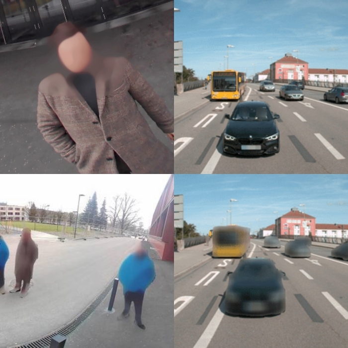
Anonymize faces, persons, license plates and vehicles on images and videos.
Deploy On-premise, Cloud, Edge, process in Real-Time.

Blur Personal Information
Automatically anonymize personal identifiable information (PII), to protect individuals' privacy.
Faces
Persons
License Plates
Vehicles
You need other object types anomymized? Let us know.
Real-Time Blurring for Mobile Mapping
Introducing Celantur Edge. Instantly blur images during mobile mapping runs.
Compliance:
Instant anonymization, no original data is stored.
Save Costs:
Avoid post-processing on expensive hardware.
Faster and Easier Project Delivery:
Eliminate time-consuming post-processing.
Mobile Mapping Privacy Challenges easily solved
By using Celantur, you can fulfill your customer's data protection demands while saving time and money.
Quality
Industry-grade detection rate, trusted by global market leaders.
Scalable and Fast
Handle massive datasets with ease.
Easy Integration
Many options to integrate Celantur into your data processing workflows.
GDPR-compliance
Comply with data protection laws like the GDPR, CCPA, etc.
More Business
Meet customer demands for new contracts and tenders
Save Costs
Fully automated anonymization, no manual labor involved.
Anonymization
where you need it.
Different projects have different requirements. Choose a solution that fits your need.
Container
Deploy the Celantur Docker container easily in your public/private cloud or on-premise. Maximum scalability.
Cloud API
Anonymize images via simple REST API calls. Data processing in the EU.
App
Easy-to-use, browser-based SaaS solution. Data processing in the EU.
Edge / SDK
SDK for edge/embedded systems, desktop software, etc.
Ask us Anything. We'll get back to you shortly
Testimonials
Trusted by industry-leaders. Here's what they say about Celantur.
"Our customers operate all over the globe and require solutions that meet the data privacy requirements that customers have come to expect in the industry. Celantur has enabled us to roll out a global solution, which we can expand and adapt according to our customers' needs. We are confident that they are the partner with whom we will be able to tackle scenarios we need to meet, no matter how complex."
Georg Schroth
CTO and Co-founder
NavVis GmbH
"With a GDPR inflicted raise of data privacy awareness, anonymization has become a critical task in the processing chain of remote sensing data.
The Celantur solution proved to be a reliable tool for the various kinds of imagery collected with RIEGL laser scanning systems. Even under difficult light conditions the software achieved an impressive detection rate."
DI Christian Sevcik
Manager Strategic Software Alliances
RIEGL Laser Measurement Systems GmbH
"Horus has been using the Celantur blurring tool for a few months now and we're very happy with the results. The tool is incredibly easy to integrate and to use. The ability to quickly and easily blur sensitive information has saved us a lot of time and effort in post-processing our data. Overall, we highly recommend the Celantur blurring tool to anyone who needs to protect sensitive information in their data."
Bas Beukers
Director Business Development & Marketing
Horus
"Celantur has helped us win well-known customers for our mobile mapping business. Their solution has made us and our users completely convinced. The cooperation with Celantur is always goal-oriented and easy-going. Simply the best solution on the market!"
Dipl.Ing. (FH) Wolfgang Probst
CEO
AllTerra DS
"Celantur is our partner in making our platform GDPR compliant. Both on technical as well as business level we have a good click and we created a scalable solution that will be beneficial for both of us."
Sander Vlotman
Managing Director
CamenAI B.V.
"Effiziente und zuverlässige Anonymisierungslösung für verschiedene Bildformate. Unkompliziertes Handling, freundlicher Service, faire Preise."
Barbara Thaler
Lead 3D Geodata Management
orbis360 SA
"With Celantur we have found a state-of-the-art solution for getting our mobile mapping solutions GDPR compliant. Their platform is easy to use, fast and the most reliable automated blurring tool we know - and we’ve tried a lot. Thanks to them we are finally able to focus fully on our core product again!"

Daniel Höller
CEO
qapture GmbH
Start with a free Demo
Sign up
Get access to our platform.
Anonymize Data
Get your images and videos anonymized.
Expert advice
Our experts will provide custom advice for applying automated anonymization on your use case.
Trust and Compliance
Data Protection is our core business. That's why we have strong measures in place to comply with the GDPR and other data protection laws.
Images are processed in GDPR-certified data centers in the European Union
External Data Protection Officer at service
All data and storage devices are encrypted
Technical and Organizational Measures (TOM), Data Protection Impact Assessment (DPIA), Records of Processing Activities, etc.
Regular & unannounced Data Protection Audits

Easily transfer Tera- and Petabytes of data
LYVE Mobile, provided by our partner Seagate, lets you easily transfer large quantities of data.
Contact UsBlur Ladybug PGR imagery
Use Horus Horison Batch Processing with Celantur Container to blur Teledyne Flir PGR images.
Read How ToWhy Celantur?
Trust
Global industry leaders put trust in our products and expertise.
Excellence
We are solving anonymization challenges, so you can focus on your core business.
Commitment
Our team is on your side, helping you on your privacy journey.
FAQ
What happens to the metadata of the original image (e.g. GPS coordinates)?
Metadata (e.g. EXIF information & ICC colour profile) is retained when creating the anonymized version of an image. Also, we can generate segmentation mask files per processed image.
Is 100% anonymization achievable?
Data protection laws like the GDPR do not state a specific "blurring rate" that has to be achieved. Instead, the use of state-of-the-art technology (e.g. machine learning) is required. We comply by training state-of-the-art machine learning models with a continously growing proprietary dataset. Quality metrics are continously measured and monitored, and can be shared with customers.
Which Mobile Mapping Systems (MMS) are supported?
Nearly all mobile mapping systems can work in combination with our solutions.
Can you process panorama, fisheye, grayscale images, etc.?
Yes. Our internal ML models are trained on a variety of the most common types of mobile mapping imagery.
Read our article "Image Anonymization for Mobile Mapping" in GIM International