Smart Cities & Mobile Mapping: Amsterdam
Learn how the city of Amsterdam uses Mobile Mapping to improve the daily work of several municipal departments.
20 January 2021Ask a question

Introduction
In the year 2000, when 360° and geo-referenced images were first introduced, the benefits for the city of Amsterdam were crystal clear.
These images, collected using Mobile Mapping Systems, gave a much better view of the state of the built environment than aerial imagery, not only through a different angle but also in higher resolution. It would deliver better views of the city’s land, buildings, and infrastructure.
What is a Mobile Mapping System?
Before getting into the details, let’s clarify what a Mobile Mapping System is.
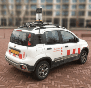
Mobile Mapping is the technique whereby a vehicle (car, boat, bicycle or other vehicles) uses special equipment to create 3D images of the environment. Through this technology, you could determine a lot of valuable data, such as the exact position of every object, its dimensions on a 3D photo.

From subcontractors to an in-house solution
As we mentioned earlier, imagery plays a crucial role in the city of Amsterdam. Many departments rely on the imagery for their daily work: from tax collection to public works management and public safety response. Updating the imagery was often necessary as the city changed rapidly.
For years, the Dutch Cadaster had commissioned a contractor to collect nationwide street-level imagery, and Amsterdam would license a portion for its use. Outsourcing to a contractor for the imagery also meant strict terms of use for Amsterdam and limited flexibility in choosing when needs to be collected.
Having its mobile mapping system enabled Amsterdam to capture street-view imagery anytime and share it with any stakeholder inside the organization.
How Amsterdam's Mobile Mapping Works
To capture the imagery, Amsterdam hired three drivers as part of a corporate social responsibility initiative subsidized by the city. This enabled the city to create employment as well as realize cost savings. After the imagery is captured, it is processed in-house.
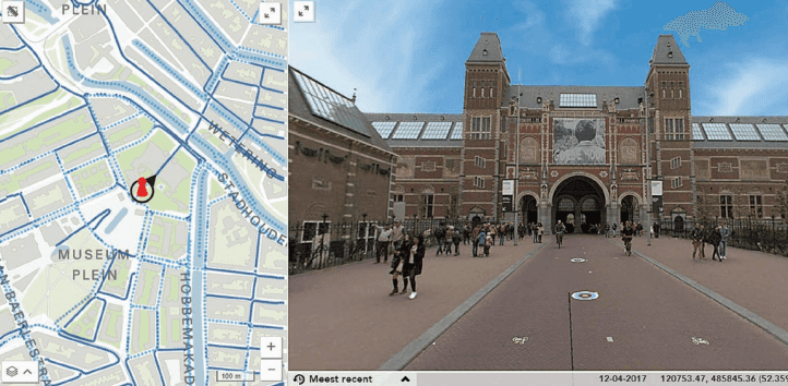
“After processing, the data is copied to a server and recognizable faces are automatically blurred. The imagery is published and shared with external users through a Web application. [...] We have published all our street-level imagery since 2004, along with maps and aerial imagery. All but private information is accessible to the public” (Ries Visser, Senior Advisor, Basic Information at the City of Amsterdam).

Departments enhanced by street-level imagery
Let’s take a closer look at which departments are benefiting from having up-to-date street-level images of the City of Amsterdam.
Public space management
Street-level imagery shows where things like traffic signs, trees and building facades are, as well as how often they change on a yearly basis. In addition, the street-level imagery provides a clear view of new construction projects when assessing real property. The city archive finds the imagery especially valuable because it gives them a year-by-year overview of the entire city.
Tax collection
People who live on a houseboat are required to pay taxes for their anchorage in the canals. Using a tug-boat with mounted MMS, it is possible to locate all houseboats. Thanks to this detailed imagery, a separate agency from the city ensure that all the houseboat owners receive a combined tax assessment that includes a payment for their anchorage.
Public safety response
Firefighters and ambulance drivers use the imagery for an overview of the surroundings before they arrive, enabling them to act faster and reduce response time.
Future plans
By 2024, the City of Amsterdam has planned to make these data widely accessible outside its organization. Data will be made publicly and freely available via a browser, granting access to citizens and companies for developing other applications. All personal data (particularly faces and license plates) will be fully-anonymized to comply with the GDPR. Why is that?
Data Privacy: Image Blurring
According to art. 4 of the GDPR, consent must be given to publicly share data that contain citizens’ personal information. However, this article does not apply to anonymized data since, per definition, is a technique that irreversibly alters data so the data subject is no longer identifiable directly or indirectly. This data is no longer considered personal data (as opposed to pseudonymization technique).
Current methods of image and video anonymization include masking, pixelation, blurring and replacement. Among them, blurring emerged as the de-facto standard anonymization method used by companies like Google, Microsoft and Apple. In fact, masking and pixelation are easily susceptible to re-identification processes, while replacement (mainly based on GAN techniques) still has high computational costs.
Want to know more about this topic? Check it out:
Summary
- Since 2000, the city of Amsterdam is using street-level images to improve the daily work of several departments.
- After a first period of outsourcing the data collection, they decided to purchase their own Mobile Mapping Systems.
- Data is processed, anonymized and shared via a browser app.
About Celantur
Celantur offers fully-automated anonymization for images & videos to comply with privacy laws. Our technology automatically detects the objects to be anonymized and blurs them:
✅ We anonymize all kinds of RGB-imagery: planar, panorama images and videos.
✅ Our cloud platform is capable of anonymizing around 200.000 panoramas and 24 hours of videos per day.
✅ Industry-grade anonymization quality: detection rate up to 99%.
Ask us Anything. We'll get back to you shortly